 |
Search the site:

|
Walking the Cliffs of Moher
Before You Embark on Your Walk:
When on the Walk: Please Leave the Cliffs and Their Environs as You Would like to Find Them. The Walks There are several walks which will match the time available and your interests. The shorter walks start at the visitors' car park while longer routes can start at several points along the cliffs. The following is one suggestion and is not intended to be adhered to strictly. It is intended merely as a guide for your enjoyment of the cliffs.
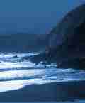
1 Car Park to Carrickatrial (Round trip: 1 1/2-2 hrs) Beneath O'Brien's Tower stands the offshore stack called Branaunmore (Brannán Mór, translated locally as 'the large stack') crowded with Kittiwakes and Guillemots during the spring and summer. Binoculars will reveal a few Razorbills nesting amongst the Guillemots high up on the stack and sometimes the occasional Fulmar and Great Black-backed Gull will join the throng. Inland is Slievenageeragh (translated as Slieve na Giorrai, 'mountain of the hare') with the high point of Knockardakin rising to 204.5m. The great wall extending northwards is Aillenasharragh (Aill Na Searrach, 'cliff of the foals'). According to Brendan Vaughan this name has its origins in pre-christian Ireland during the time of the legendary Tuatha de Danaan when sorcery and druidism were practised. After St Patrick had introduced Christianity, however, the old rituals were slowly abandoned. But in protest the Tuatha de Danaan used their magic powers to turn themselves into horses and galloped to Kilcornan, where they hid for centures in the Kilcornan caves. Time passed and the horses were forgotten until one day seven foals emerged from the caves. They were frightened by the bright daylight and bolted, galloping all the way to Aillenasharragh where they met their awful fate. The highest point on the cliffs is marked by an overhanging slab - an inviting platform. But take care if you venture on to it - there is nothing but fresh air between you and the boulder beach 200m below (a fact that becomes apparent only when you look back at the cliffs from Carrickatrial). The path is narrow and close to the cliffedge for much of this route and it is advisable to walk on the landward side of the flagstone wall. Care should be exercised too on the descent towards Carrickatrial. The path is broken and can be slip pery in damp conditions. Follow the cliff edge across the stream which plunges over the cliff to your left, and continue onto the flat-topped promontory known as Carrickatrial (Carraig a Thriail, 'rock of the trial', origin not known). This provides a spectacular view of most of the cliff face southwards to Hag's Head and from this vantage point you will get a better sense of the scale of the cliffs which otherwise tends to be lost when viewing them against the backdrop of the vast ocean. On the sloping, grassy south face of Carrickatrial there is a steep, narrow, zig-zagging path which leads down to the foot of Aillenasharragh. However, this path is potentially very dangerous and you are recommended not to attempt a descent. From Carrickatrial you can turn to the car park by the same route or walk eastwards in the general direction of the stream back to the road which, on turning right, will take you back to the car park.
|
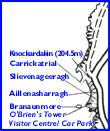 Take the steps up to O'Brien's Tower (please avoid walking on the grass in order to reduce the erosion pressure which is already apparent). You can share the privilege of Cornelius O'Brien and his guests by climbing to the top of the tower, but the steep climb up the spiral iron staircase will not really enhance your view of the surrounding landscape.
[ Back to Top ]
All Material © 1999-2004 Irelandseye.com and contributors