|
Roe Valley Country Park
Specs
• Length 10km (6 miles)
• Ascent 90m (300 ft)
• Time 3 hours
• Sheet 7
• Start from Dogleap Centre in the park (679203)
• Pleasant, interesting woodland walks along the River Roe.
How to get there:
Take the Dungiven road (B192 or B68) out of Limavady and watch for a signpost to the Roe Valley Country Park.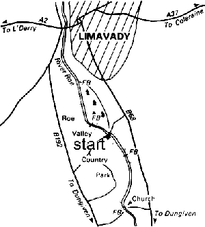 Visit the Dogleap Centre first of all, where there is much information about the park, including a leaflet guide and a booklet on the Wet Woodland Walk. Nearby is a museum and the old hydro-electric power house, first opened in 1896. The park extends for about 5km (3 miles) along the Roe and this walk takes in the entire length. It is of course possible to choose a shorter walk, using the footbridges that cross the river. On the other hand, the whole day could easily be spent here studying the remains of the old mills, weirs, mill races and machinery.
First part:
Start the walk at the Dogleap Centre and take the path leading upstream on the same side of the river. Pass an old bleach green look-out tower near the river and, just before the second tower, take the path to the left leading into the trees and over a little stone bridge. The path continues between the river and an old mill race. The deciduous woodland along the river is particularly colourful and picturesque in the autumn. Reach a weir with a small gravel beach just before it and the entrance to the mill race. The river is famous for its salmon and trout and attracts many anglers, as well as visiting herons.
Cross the river at the first footbridge and turn right, upstream. Just after another weir at a bend the sides of the river become steeper and rocky. These are the Carrick Rocks, and at the next weir and small beach the path climbs up to emerge in the grounds of a pretty little parish church. To the right of the church the path leads down through the trees to another footbridge. At the top of the steps on the other side turn right at a small car park and follow the path along and down through some woodland - various small tracks here all lead down to the river. The path eventually levels out along between the river and a mill race. Cross the footbridge again and continue downstream, passing under the remains of an old mill wheel. The final section has some boardwalks (careful when wet!) and then a grassy path leading to an area by the river designed to be used by people in wheelchairs. Cross the road-bridge back to the Dogleap Centre. A break may be taken before doing the second part of the walk. This first part takes about 2 hours.
Second part:
For the second part of the walk, cross the bridge again and turn left downstream. Pass the herb garden on the left, then bear left at a fork and reach the site of O'Cahan's Castle, above the river. Follow the path, bearing left at another fork and coming to O'Cahan's Rock, a precipice some 25m (80 ft) above the river. Take the path on down and round to the left; near the river is a little round stone summerhouse, close to a weir. From here either follow the path close to the river or go alongside the mill race, with several little stone bridges across it on the way downstream. Cross the river at the next footbridge and continue upstream on the other side. Keep alongside the river until you reach the weir near a footbridge at O'Cahan's Rock. Here you may see the hoof mark in the rock where O'Cahan's horse landed after jumping from the clifftop opposite! At the weir take the path leading up to the right (marker post no. 10 on the Wet Woodland Walk). The path, now up above the river, goes along and through a gateway with the caravan site on the left, then back out to the road at the car park.
see also: Advice on leisure walking
|
|