 |
Search the site:

|
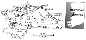
Connemara & The Burren
Some of our party (on Ben Lettery) called for the provision basket. It was little short of treason against the majesty of nature, to fix those eyes on rolls and cold beef, which ought to have been directed to one of the noblest views of Cunnemarra. First Connemara, that is the Twelve Bens, the Maamturks and the Benchoonas. All three ranges are in west Galway and separated from the mountains of south Mayo only by Killary Harbour. This is a small but highly varied area, much of it bereft of the evidence of humankind, yet not all that remote, and in all very rewarding. The Burren in County Clare is quite far away from Connemara and is included in this region only because it fits in even more incongruously elsewhere than it does here.
The Twelve Bens, also incorrectly called "the Twelve Pins", a magnificent cluster of steep-sided, bare, rocky quartzite "haystacks", cover a tiny area (less than ten kilometres/six miles in any direction). Some of the Bens are in the Connemara National Park and contain the nucleus of a recently introduced herd of red deer. Though they rise to only 730 metres/2,395 feet at Binn Bhan/Ben Baun (route 93), the seventeen or so peaks in this range appear to be very much higher and the long, steep descents and re-ascents between peaks make most walks within them quite arduous. Navigational problems are not as acute as might appear at first glance - the narrow ridges virtually exclude all but the most gross errors, though these, if they occur, could involve lengthy and difficult retreats. Because of the lack of vegetation on the tops and slopes, these hills are exceptionally dry underfoot. In contrast, the valleys are normally very wet and should be avoided. The most popular routes are high-level circuits of the tight horseshoes surrounding the valleys (routes 92 to 94). Like the Twelve Bens, the Maamturks are a bare, rocky quartzite range rising to a somewhat lower height, Binn idir an Da Log (703 metres/2,307 feet) being the highest peak. Like the Bens, they are generally dry underfoot and command marvellous views. Here the resemblance ends because, as has been observed: "The Maamturks are the Bens, straightened out and with the tops sheared off". The Maamturks form two shallow arcs (the smaller is named on the maps as part of Joyce Country), in all about twenty kilometres/twelve miles long. It is this near-linear configuration which makes looped walks difficult to devise. The tops form a virtual plateau slashed by a set of steep-sided passes which are heart-breakingly arduous to traverse on routes along the spine of the range. This plateau and the numerous unwanted cairns in places make navigation particularly difficult in poor visibility, so that the excellent mapping is of a great help. Careful study on the map of the details of the proposed route is advisable.
The Western Way runs through a gap in the Maamturks and along its flanks; though it is not waymarked at present, it is useful in forming the lowland section of looped walks. The Maamturks Walk, considered by many to be the toughest of Ireland's marathon walks, takes place every year in May or June; the route is usually north-west to Leenane. Access: the N6 (Dublin to Galway road), the usual approach to Connemara, is fairly good, though the roads west of Galway are narrow and bumpy. Clifden, on the remote western out skirts of the region, is about 300 kilometres/185 miles from Dublin; Larne is about 400 kilometres/250 miles and Rosslare Harbour about 350 kilometres/215 miles away. Galway has the nearest railway station and a small airport. There are express buses to Clifden from Galway via Roundstone and from Westport via Leenane, both operating in the summer only. Roads and accommodation: travel by road within Connemara is surprisingly easy. The N59 runs near all the ranges and the R344 runs between the Maamturks and the Twelve Bens but is of little use for the latter because a line of lakes and a swathe of forest greatly impede an approach from the road. The biggest centre by far in Connemara is Clifden, though even it is modest. There are several other smaller centres, for instance Letterfrack and Recess. Tiny Leenane, as stated previously, is well placed for much of Connemara and equally well placed for the mountains of South Mayo.
Local bus services follow variations of the express routes (they leave the N59 to call to surrounding villages) so that the region is generally quite well served by public transport. The Burren is quite easy to access, has several small towns close to it and has express bus services running through Ballyvaughan and Lisdoonvarna. The local bus service is quite poor.
Though it may now be a little out of date, the Connemara map/guide contains a map at 1:50,000 which is explicitly designed for walkers. Its boundaries neatly encompass the three ranges in Connemara and it shows cliffs comprehensively, the only map in the Republic to do so. For this reason, it is given as the reference map for the area it covers.
Route 92: South Twelve Bens Start at Ben Lettery Youth Hostel on N59 (L 777483). Climb Ben Lettery/Binn Leitri directly from youth hostel; climb Binn Gabhar. Climb Binn Bhraoin by easily avoidable scree slope, walk along summit plateau north, then north-east and take steep rocky descent north-east (not east) to col at Mam Eidhneach (L 788527) (escape possible here but make for track at L 806501 to minimise wet ground). Climb Bencollaghduff, descend to col at Mam na bhFonsai, climb east, then south east to Binn Chorr. Climb Derryclare and, to avoid cliffs to right, continue south for l.5 kilometres before veering right to pick up track. If, alas, there is no transport here, walk track for two kilometres and N59 for l.5 kilometres.
Distance: 16 kilometres. Climb: 1,600 metres.
A short introductory walk in the Bens is to take the above route to Binn Gabhar, retrace steps to cairn between it and Ben Lettery and climb Binn Ghleann Uisce. Descend west to forest (shown much higher on map than in reality) and follow it to track. Track and N59 to start.
Distance: 10 kilometres. Climb: 700 metres.
Route 93: North-East Twelve Bens Gleann Eidhneach Horseshoe Start at junction of side road and R344 (L 819562). Walk side road for 200 metres, then climb Knockpasheemore, Binn Bhan (trig pillar), descend steeply (avoiding crags) to Mam Lidhneach (escape possible here). Climb Bencollaghduff, descend to col at Mam na bhFonsai, climb north-east to Binn an tSaighdiura, Binn an Choire Bhig, descend steeply (avoiding crags) to river at about L 812551, cross it here and meet track.
Distance: 13 kilometres. Climb: 1,200 metres.
Related article on The Burren .
|
[ Back to Top ]
All Material © 1999-2004 Irelandseye.com and contributors